Saturday, October 29, 2011

Ajanta and Ellora


Cave no 1, originally uploaded by atanu.maity.
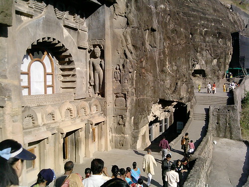
Located near the city of Aurangabad in Maharashtra, the famous Ajanta Ellora caves are shrines cut out of rock, by hand, and rank amongst some of the most outstanding specimens of ancient Indian architectural heritage. The 34 caves at Ellora and the 29 caves at Ajanta, remained shrouded in obscurity for over a millennium, till John Smith, a British Army Officer, accidentally stumbled upon them while on a hunting expedition in 1819. Ajanta has been designated as a World Heritage Site, to be preserved as an artistic legacy that will come to inspire and enrich the lives of generations to come.

The caves of Ellora are about 30 km from Aurangabad. Whereas the Ajanta Caves are noted for their paintings, here it's the sculpture that is remarkable.

Pavana dam, Lonavala


Pavana dam, Lonavala, originally uploaded by atanu.maity.

Pawna Lake (Pavna Lake) is an artificial lake formed by the Pawna Dam built across the Pawna River nearby Lonavala. The lake attracts many tourists due to its imposing natural ambience and cool climate. From the dam site one can view the majestic sights of Tungi, Logagarh and Tikona forts.

Friday, October 28, 2011

Ganeshpuri Temple, Maharashtra

The town of Vajreshwari - on banks of river Tansa - lies in Bhiwandi taluka, Thane district, Maharashtra, India and 31 km away from the nearest railway station of Vasai. The temple is located near the post office of Vajreshwari town, on the Mandagiri hillock, which was formed out of a volcanic eruption and is surrounded by hills on all sides.

Saturday, April 24, 2010

Travel Diary : Goa


Anjuna beach, Goa, originally uploaded by atanu.maity.

The famous Portuguese enclave of Goa, one of the India's gems, has enjoyed a prominent place in the traveler's lexicon for many years. The main reason for this is its magnificent palm-fringed beaches and renwewd travelers scene. Yes it offers much more than just the hedonism of sun, sand and sea.

Goa has a character quire distinct from rest of the India, Despite more than three colonial rule, Roman Catholicism remains a major religion in Goa.

Goa Beache are much ahead of other beaches in India in terms of popularity and the facilities that are available here. The beaches here have been accepted as a matter of life, there are exotic cuisine backing the pleasure of have on sun and sand, and water sports facilities that include from water scooters to water gliding. To add on you can shake your legs for some time with a glass of feni and beer, engaged in shopping on the beachside, or have midnight bonfire on the beach.

There are some more aspects of Goa beaches that attract tourists every year. Whatsoever times you have visited these beaches they tend to change their look and get new designs every new season. These beaches refurbish themselves every new season and enhance the excitement of visitors who are never tired of appreciating Goa. Out of 125 km of coastline the beaches of Goa cover not less than 83 km and there is one for you also waiting to be explored. Go and find it!

Most popular goa beaches are Agonda Beach, Aguada Beach, Anjuna Beach, Arambol Beach, Baga Beaches, Benaulim Beaches, Bogmalo Beach, Calangute Beach, Cavelossim Beach, Colva Beach, Dona Paula Beach, Mabor Beach, Majorda Beach, Miramar Beach, Palolem Beach, Vagator Beach, Varca Beach

Sunday, January 31, 2010

Travel Diary : Tungareshwar, Vasai


Tungareshwar, Vasai, originally uploaded by atanu.maity.

Tungareshwar is at an altitude of about 2177 feet, one of the highest mountain plateaus in Vasai. Green Forest, water way, rock, perfect palce for day picnic, near Mumbai.

For most trekkers the starting point is the western highway junction, which is about a kilometer from the base. At the base there is a forest check post. From this point onward starts the actual trek of Tungareshwar. After about a 3 km hike and walking through two streams, you reach the Lord Shiva temple. his place is frequented by pilgrims and at times can be crowded so it is preferable to avoid weekends. For many picnickers this is the destination for enjoyment. A visit to the temple and a swim in the overflowing water pond is all they want out of this outing.

For the real trekker to Tungareshwar this is the first halt. From this point there are two options:
1. A trek right up to the top that is 8 km long (2 hours for average person one way)
2. A jungle trek to the Chinchoti waterfall (1 hour for an average person one way)
Both these treks are enjoyable and have their own charm. No amount of written words can describe this wonderful experience.

Thursday, December 17, 2009

Travel Diary : Meghalaya


Meghalaya, originally uploaded by atanu.maity.

Created in 1971, this state is the home for Khasia, Janita and Garo tribes people. The hill station of Shillong is the state capital wile Cherrapunji, 58 km away, was until recently said to be the wettest place on earth, with an average annual rainfall of 1150 cm, nearly 40 feet! In one year 26.46 rain fell. Nearby Mawsynaram recently took the title from Cherrapunji.

It's no wonder Meghalaya means Adobe of Clouds.Other palce of inteest around the state include Jakeram with its hot springs, Kayallng Rock at Mairang, Mawjymbin Cave at Mawsynram and Umiam Lake.

Going Around

Shillong

The capital of the state of Meghalaya, known as the Scotland of the East - Shillong is a pretty hill town with lakes, grassy downs, pine scented hillsides, English cottages and a fine golf course.,This pleasant hill station, standing at 1496 meters, is renowned for its climate and breathtaking views. The state museum covers the flora, fauna, culture and anthropology of the state. The town has number of parks and gardens.

The town has a number a number of parks and gardens. The Crinoline Waterfalls and near Lady Hydary Paerk and there are various other waterfalls around Shillong. The town takes its name from the 1960 meter high Shillong Peak, from where there are fine views, its almost 10 km from the center.


Getting There

A good road runs the 100 km from Guwahati in Assam to Shillong, You can also take a chopper ride which will take about 30 minutes from Shillong helipad to Guwahati Airport. From Guwahati you can take buses which is run frequently and also can take sharing taxi to reach Shillong.

Friday, December 11, 2009

Travel Diary : Matheran


Hill View, Matheran, originally uploaded by atanu.maity.

Matheran is the nearest hill station to Mumbai, The names means Jungle Topped or Wooden Head. It is a city and a municipal council in Raigarh district in the Indian state of Maharashtra. It is a hill station in Karjat Tahsil. It is the tiniest hill station in India. It is located on the Western Ghats range at an elevation of around 800 m (2,625 feet) above sea level. It is located at 18.59° N 73.18° E, around 90 km from Mumbai and about 120 km from Pune. Matheran's proximity to the two cities makes it a popular weekend getaway for urban residents.

Matheran was discovered by Hugh Malet in 1850. The British developed Matheran as a popular tourist resort.

At an elevation of around 800m (2,625 ft) above sea level Matheran is a hill station located about 100 km from Mumbai. Matheran literally means jungle on top. All vehicles (Except emergency vehicles) are banned here. The only modes of transport are on Horseback, by man-pulled rickshaw, or on foot. Every one living in cities needs this sort of change once in a while.

Old British-style architecture has been preserved in Matheran and most structures are now heritage structures.

Matheran has been declared an eco sensitive region by the Union Environment Ministry (GoI). Quite uniquely, Matheran is free of all forms of motor vehicles, amking it in unbelively tranquil repite after the congestion of Mumbai. It is ringed by many km of walking tracks, while lead to lookouts that drop sheer to the plains. On a clear day the views are fantastics.

Getting to Matheran is the half the fun; from Neral junction you take a tiny narrow-gauge toy train up to 21 km route to the hill station. It's a two hour ascent as the train winds its way up to steep slopes and, at one point, passes through tunnel.

Going Around

Porcupine/Sunset Point is a good place for ctaching the sunset, but Panaroma Point, at the extreme north, is said to have the finest views. The western side, from Porcupine to Luisa point, is known as Cathedral Rocks, and Neral can be seen far below, straddling the central line, At the south, naer One Tree Hill, is a trail down to the valley blow known as Shivaji Ladder.

Getting There

Train from Mumbai CST, only a few of the Pune express stop at Neral Junction. If you are back to Pune or Mumbai after Matheran, It is best take local train first to Karjat and then pick up one of the frequent trains from there. From Neral you can take share taxi or Toy train to reach Matheran. Most of the year the tpy train leaves from Neral to Matheran at 8:30, 11:00 and 17:00.

Travel Diary : Trimbakeshwar, Nasik


Trimbakeshwar Shiva Temple, originally uploaded by atanu.maity.

Trimbakeshwar or Tryambakeshwar or Trambakeshwar is an ancient Hindu temple in the town of Trimbak, in the Nashik District of Maharashtra.


Trimbakeshwar - one of the holy places of not only Maharashtra but the whole India is near Nashik. Trimbakeshwar is one of the twelve Jyotirlingas in India. There is no sacred place like Tryambakeshwar, no river like Godavari, no mountain like Brahmagiri etc. The reasons for its being so sacred are - Godavari river originates in this place, its a place of Tri-Sandhya Gayatri, the birth place of Lord Ganesha


Trimbakeshwar is a religious center having one of the twelve Jyotirlingas. The extraordinary feature of the Jyotirlinga located here is its three faces embodying Lord Brahma, Lord Vishnu and Lord Rudra.

Travel Diary : Bramhagiri, Nasik


Bramhagiri, originally uploaded by atanu.maity.

The first peak of Sahyadri is called Brahmadri. The story associated with this is that Shankar was pleased with Brahmadev and said “ I shall be known by your name”. Hence it is called as Brahmagiri. The mountain is 1800 feet high . Its height from sea level is 4248 feet. Five peaks of this mountain are called Sadyo-Jata, Vamdev, Aghora, Ishana and Tat-Purusha and are considered as five mouths of the Lord Shiva and they are worshipped.

Gangadwar is half way to Brahmagiri mountain. There is a temple of Ganga, now known as Godavari River. Ganga appears first time here, after it vanishes from Brahmagiri Mountain. Godavari comes to Gangadwar from Brahmadri

Original Ganges and Trimbak Tirtha are on Brahmagiri mountain adjacent to Trimbakeshwar temple.


Thursday, December 10, 2009

Travel Diary : Panchavati, Nasik

Panchavati, Ramkunda and Tapovan - Nasik

The 'Ganges' of the south, Ramkund in the sacred river Godavari, draws countless pilgrim every year. The popular belief is that Lord Ram had his bath here, at some stage of his exile. To commemorate that the devotees frequents here to have a holy dip.

In 1696, Chitrarao Khatarkar built a holy tank on the spot where it is believed that Rama and Sita took their bath. Devotees gather here to plunge their beloved’s ashes on the strong belief that it will help the dead to get salvation.

One among the alluring picnic spots, at Ramkund the river Godavari takes a 90 degree bend and that spot is considered as the most holy by the pilgrims.

Panchavati is a famous religious and pilgrimage place in India. he name is derived from the Sanskrit for Banyan Tree. It has been proposed to identify it with the modern Nasik, because Lakshmana cut off Surpanakha's nose (nasika) at Panchavati. According to Hindu legends and Ramayana Rama, along with his wife Sita and brother Laxman, stayed in Panchavati during their Vanvasa period. The famous Laxman Rekha is located in Panchavati about a kilometre away from Sita Gupha. It was from here that Ravana abducted Goddess Sita. Today this area is a major pilgrimage and tourist attraction. Panchavati is one of the coolest and cleanest area of Nasik. It has got many temples like Kalaram Madir, Goraram Mandir, Sita Gupha. There are many temples in Tapovan which is very close to Panchavati and can be considered to be in Panchavati.